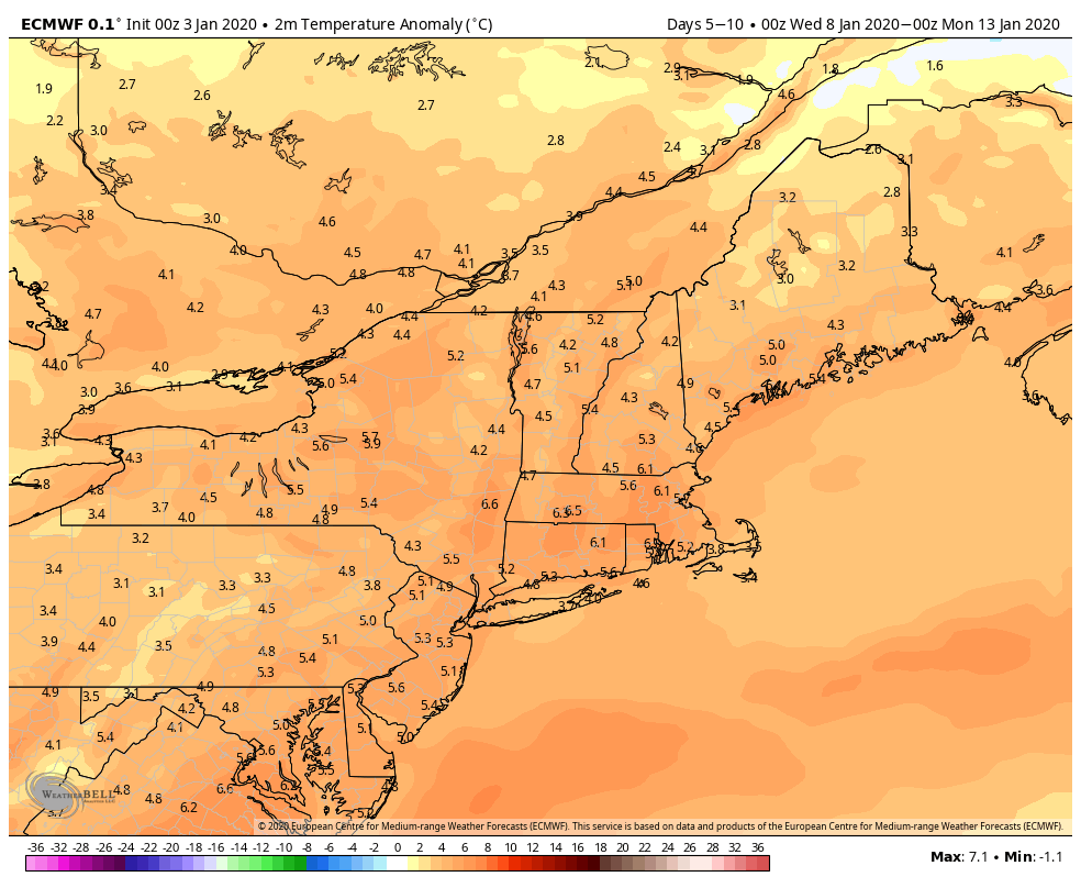
Perhaps the most commonly heard phrase from clients this winter is… Where did winter go? It seems like we get some cold, even some snow, and within a couple days the whole pattern breaks and it’s warm & rainy. Well, we have some better news. In the January 4th blog we outlined the thaw through …
Category Archives: Vail Resorts
The Bad News, The Good News
As we hinted at in the last blog, we’re at that dreaded “thaw” point with the “R” word in the forecast much more than any of us would like to see. What was foreshadowed has unfortunately played out as planned, however we did see a bit more snow in the days preceding the rain than …
Temperature and Storm Rollercoaster
While winter is showing up in doses, the sustained cold is having trouble hanging around. That leaves us in a progressive and volatile pattern, with temperature swings and mixed precipitation storms and outputs. Each storm will determine its dominant precipitation type – whether we have cold air damming and can hold some cold, or we …
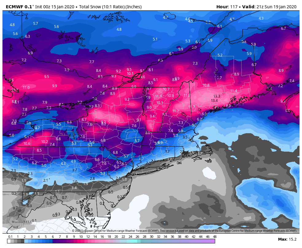
Why The Cold Will Hold
A similar structured system (but not in the cold distribution) to the storm that brought us over 2 feet of white gold exactly 4 weeks ago, is about to bring significant ice, snow, and rain to Vail Resorts properties up and down the eastern seaboard. This is a one-two punch – first with the warm …
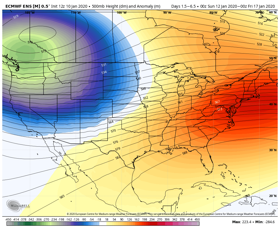
Teleconnection Testament & Polar Vortex Explained
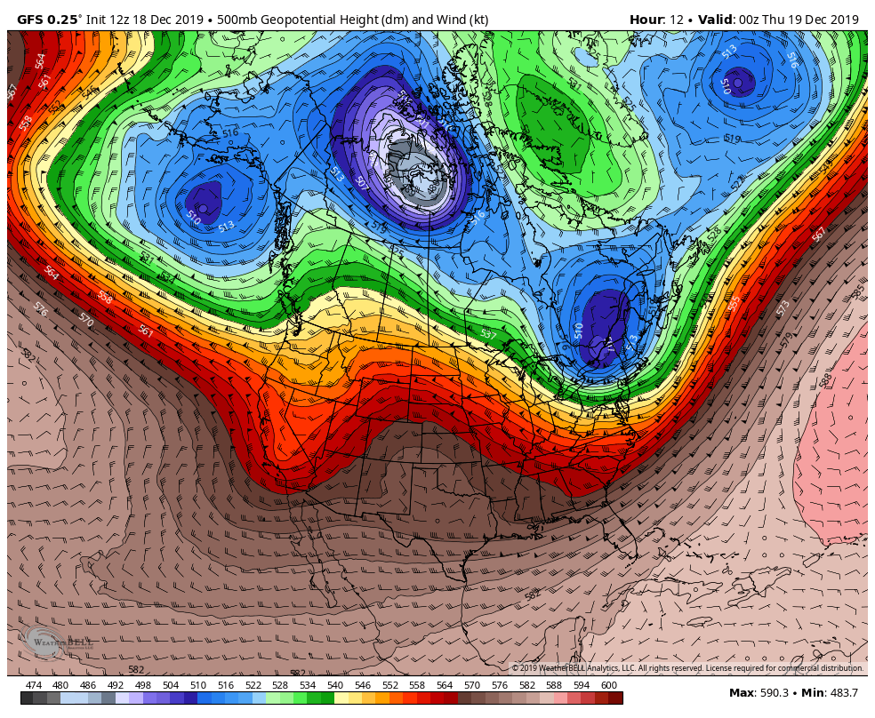
Our last blog was about teleconnections and some signs that our 12/17 system would likely be cooler than the washouts we had previously. We spoke of freezing rain and rain for PA (which was more freezing rain than rain), snow/ice for Hunter & Mount Snow, and all north snow. Mount Snow was mostly snow – …
Continue reading “Teleconnection Testament & Polar Vortex Explained”
Teleconnections Telling The Story
It’s hard writing forecasts with the R word in it – especially after the large mass of snow received just over a week ago at Hunter & Mount Snow. Unfortunately, we have one more warm system to go through before we can think about the possibility of snow. Why are we getting the warm, inside …
Why is the cold air going around some of Vermont?
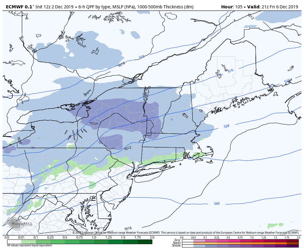
On Thursday, Dec 5, we had a cold front come through New England that was forecast to drop temperatures during the day. As this was occurring, I started to notice something that had happened a couple times in the past – southern Vermont cooling faster than central and portions of northern Vermont. With clients from …
Continue reading “Why is the cold air going around some of Vermont?”
Long Term Trends
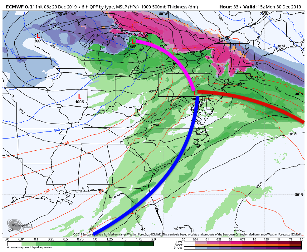
As we come off of a long duration snowstorm, our sights are set on what’s coming next. In previous blogs, we’ve been talking about an arctic outbreak, along with a moderation, and a continued volatile pattern until mid to late December. That’s our next few weeks in a nutshell. After the coastal system departs, we’ll …
Major Winter Storm Update
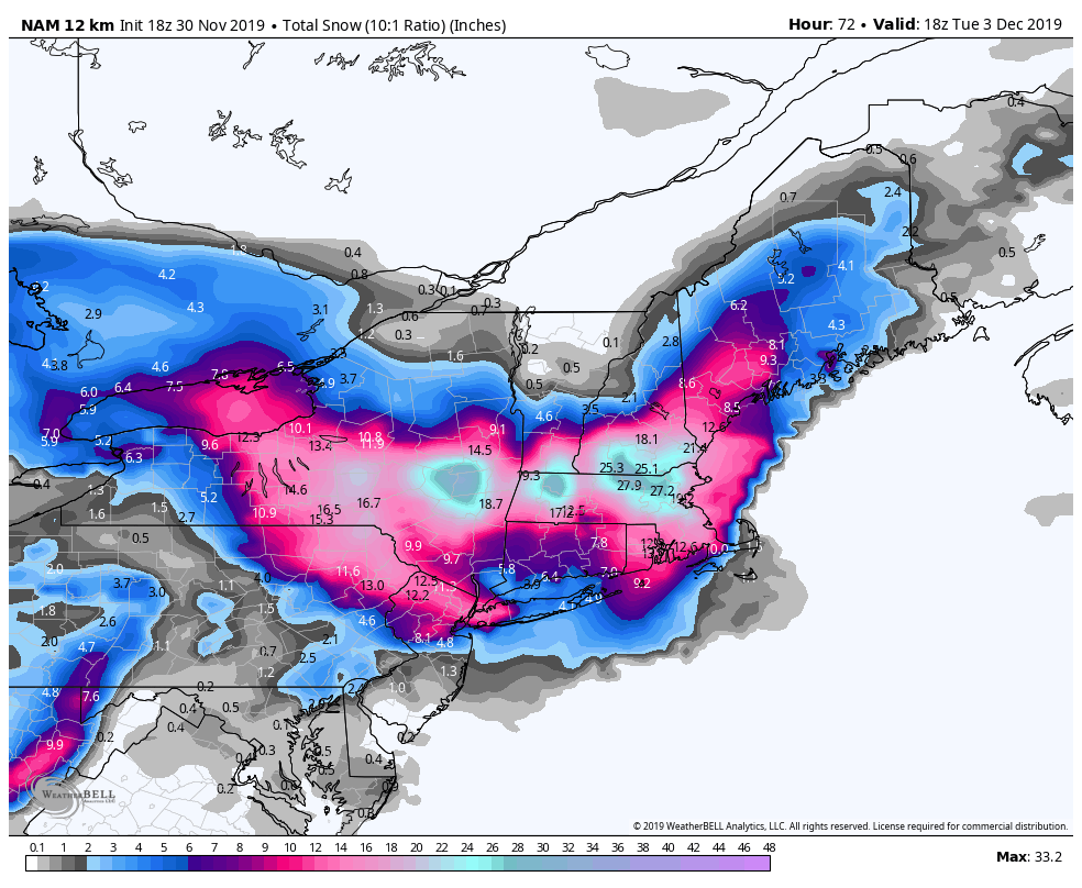
With the largest storm of the season heading towards us Sunday, here’s another update to supplement the video update from Friday. We’re still looking at a large swath of heavy snowfall from central NY to southern VT & NH – putting Mount Snow & Hunter in the prime positions to take home a gold medal …
Thanksgiving Week Forecast Thoughts and Beyond…
The pattern has exploded with energy and doesn’t show many signs of stopping. Our Sunday system brought a variety of precipitation types, erratic temperature movements and ultimately takes us out of snowmaking zones (for the most part) until Thanksgiving morning. Temperatures Monday don’t rebound much, but we’ll be above freezing at most base and mid …
Continue reading “Thanksgiving Week Forecast Thoughts and Beyond…”