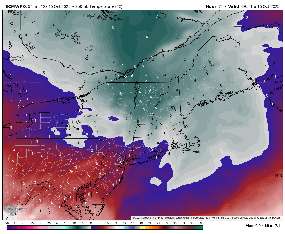
We are officially halfway through the month of October, and there’s two main points in the long-term forecast — *There’s no substantial cold on the horizon*There’s no substantial rain on the horizon Fall remains in full control as we head through the second half of the month. While rain chances will be quicker than once …
Category Archives: Killington
Season’s Farewell – A Look Ahead 4/27

Many still-open resorts are saying farewell this weekend to the 24-25 season, which was one of the more consistent winters we’ve had in some time. Despite being a month into spring, winter is still holding on at times, which we’ve seen today with snow falling in the higher elevations of VT, NH & ME. We’ll …
Unsettled Pattern Continues (still) 4/15
The sun continues to be a mystical feature that isn’t often seen, but every couple of days we get a nice view and moment of warmth before the next cool/moist airmass settles in. Yesterday was one of those days – a stunning bluebird day for many — and we’ll have a bit more today before …
Relatively Cool, Sometimes Wintry Pattern Continues 4/9
Not much has changed since we switched into April, now that we are heading into the middle of the month. The pattern remains quite unsettled, overall on the cooler side, and a sunny day is a hot commodity. While we enjoy some sun for Wednesday and early Thursday, the clouds come back in during the …
Continue reading “Relatively Cool, Sometimes Wintry Pattern Continues 4/9”
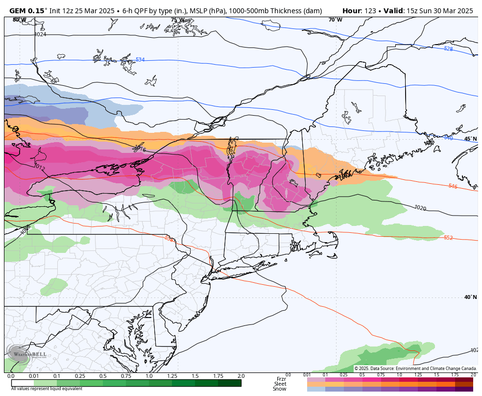
Unsettled Week Ahead 3/31
Despite having the ingredients for what should be wintry events, the time of year is having an effect on the outcome. The negative NAO can’t hold in enough cold air for the storm this week, even with a trending positive PNA. We’ll have a cold front move through tonight, dropping temperatures into Tuesday morning (though …
Pattern Transitions with Icing Concern This Weekend
As nice as January and February were, it was a struggle to enter March without much break from the warmth along with numerous rain events and ill-timed flash freezes. We finally made it through the 20-25th period of transition and are now squarely in a negative WPO scenario through most of April. The stronger sun …
Continue reading “Pattern Transitions with Icing Concern This Weekend”
Warm March Madness On Limited Time 3/13
Since our last blog, I’ve been watching the long term pretty closely as we progged March 20th as somewhat of a turning point of our first substantial warm period of the season. The teleconnections continue to paint the picture of the change but the deterministic runs have not — ensembles are a bit better so …
Rollercoaster Start to March – Long Term Thoughts 2/28

Late January into February was a fairly snowy and cold blitz from the Mid-Atlantic to New England. It’s been a winter that’s officially wintered — which I don’t think we can say has happened in quite a few years. Tomorrow, March 1 begins meteorological spring. Despite the snowy start that some of us will have …
Continue reading “Rollercoaster Start to March – Long Term Thoughts 2/28”
Storm Pattern Continues 2/13

This was supposed to post yesterday, but somehow got stuck in the queue — therefore here’s an early morning blog for your wintry Thursday. This morning, we are watching another storm system come through the area with mixed precipitation. Reports of freezing rain are coming in from the Berkshires, the southern Adirondacks and Green Mountains. …
Topsy Turvy (Temperature) Pattern 1/29
We’re going into our second 24 hours of temperatures moving in opposite directions than they usually do, as we have arctic fronts and low pressure systems altering the normal diurnal trend. There are few days in the 7 day forecast that don’t have a “rise” at night or “fall” during the day, so I wanted …