A similar structured system (but not in the cold distribution) to the storm that brought us over 2 feet of white gold exactly 4 weeks ago, is about to bring significant ice, snow, and rain to Vail Resorts properties up and down the eastern seaboard.
This is a one-two punch – first with the warm front, and then with the coastal low that develops. Really, it could be considered a one-two-three punch as we wait for the upper level low to move over the region, but it will not be nearly as impactful as the first two.
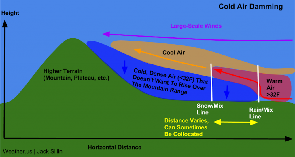
Let’s take a look at the setup for this storm system. We briefly touched on cold air damming in the video blog, and we’ll do a deep dive into that after the system is gone, but there are some key features that are leading to this scenario.
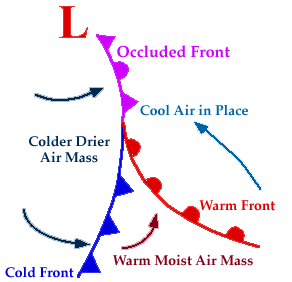
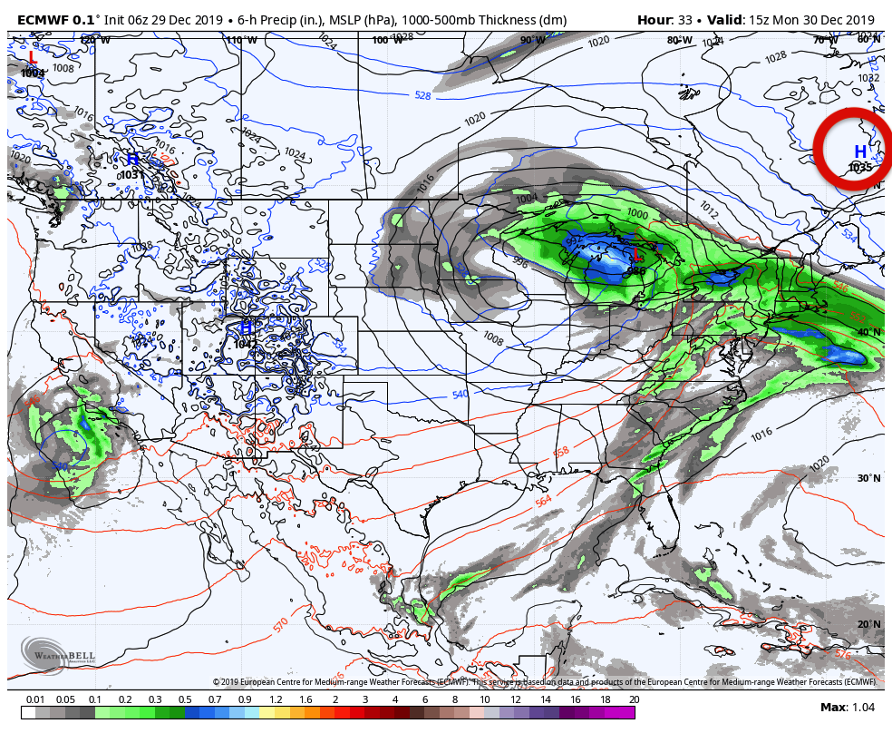
First, the overall view. I’ve drawn the fronts in solid color lines to show the delineation of the boundaries. The blue is the cold front, and the red line is the warm front.The purple is the occluded front – occluded fronts occur when the cold front catches up with the warm front, and is therefore a boundary between the old cold air mass, and the new cold air mass.
The “old cold” airmass is the body of air that has been in place for the past several days. In a previous blog, I believe about the teleconnections, we spoke about the perfect high pressure positioning for us to get solid winter storms. The ideal position was due north of Lake Ontario in western Quebec. Notice the high positioning is farther east, and this is a big reason for the current situation with cold air damming.
With the high to the east, we have clockwise winds around high pressure – that brings in colder air into the NE from Canada. But it’s bumping up against the warm front, therefore we now have a battle ground zone – cold air is more dense and heavier than warm air, so it will begin to win the battles where it can, and you start to notice the isobars (lines of equal pressure – always black lines on the maps) kinking toward the south.
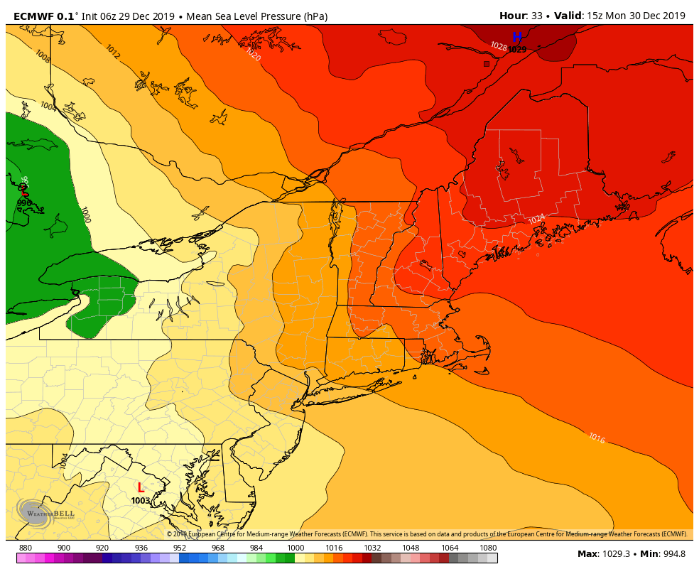
I’ve added a separate view of the Euro surface pressure map without any other variables on it. Look at how the isobars kink toward the low pressure in Northern Virginia. This is a classic pressure pattern look for cold air damming.
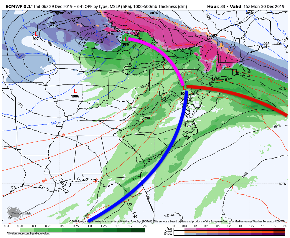
So you have the cold air from the high pressure in Canada bumping up to the warm air coming in from this system. Warm air glides over the cold air – we have a large moisture stream from the Gulf of Mexico (there will be a severe weather outbreak along with this too on Sunday) – and there is your icy setup. The summit of the mountain sometimes ends up with all rain – depending on where the warm layer comes in. That will shift a fair amount in this storm, so summits will really run the entire range of precipitation types.
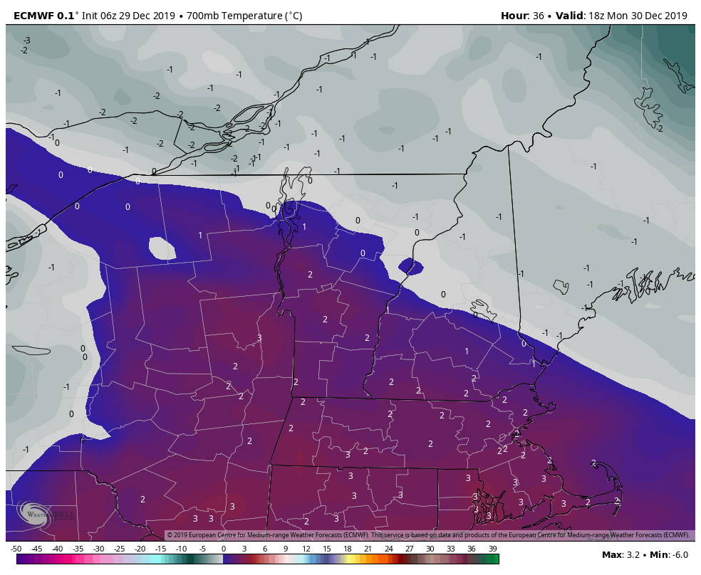
The icy piece of this is only with the warm front – part one. We then have a strengthening low off the New Jersey coastline that will change the temperature profile through the atmosphere, and eventually eliminate the warm layer aloft with counter-clockwise winds doing their work. Notice in the 700mb layer (usually 7,500-10,000 feet), how we move temperatures from 2°C Monday afternoon to -5°C by Monday night. This will change everything back to snow to finish off the event, though the heaviest snow will effect NH/ME more than NY/VT. This is likely where Attitash/Wildcat win out this storm for us. Of note, also notice the warming along the ME/NH/MA coast – that’s indicative of the low pressure winds taking over the overall wind flow, as warmer ocean air raise temperatures along the coast.

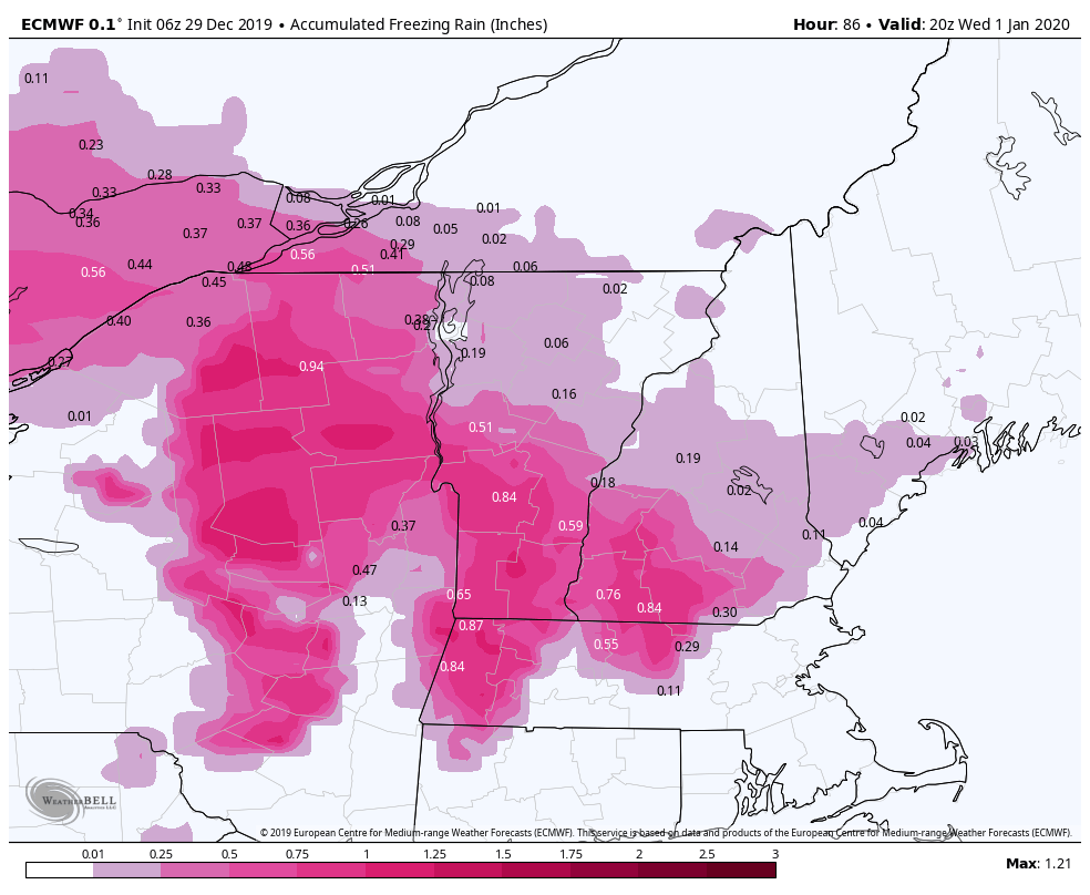
This is an entire rain event for our Pennsylvania resorts. However, an inversion will likely develop at Hunter to provide some icing at the base area. I don’t believe it’ll be as impactful as what we’ll see at Mount Snow, but icing will be a concern for operations on Monday. Icing at Mount Snow looks to be highly impactful – over .50″ of ice accretion is possible, which is considered significant by utilities for power outages. NWS has also issued an Ice Storm Warning in MA just south of Mount Snow, which confirms the possibility for high ice amounts. Behind the icing, we’re still looking at accumulating snow – most likely 2-4″, but could be up to 6″ for Mount Snow.
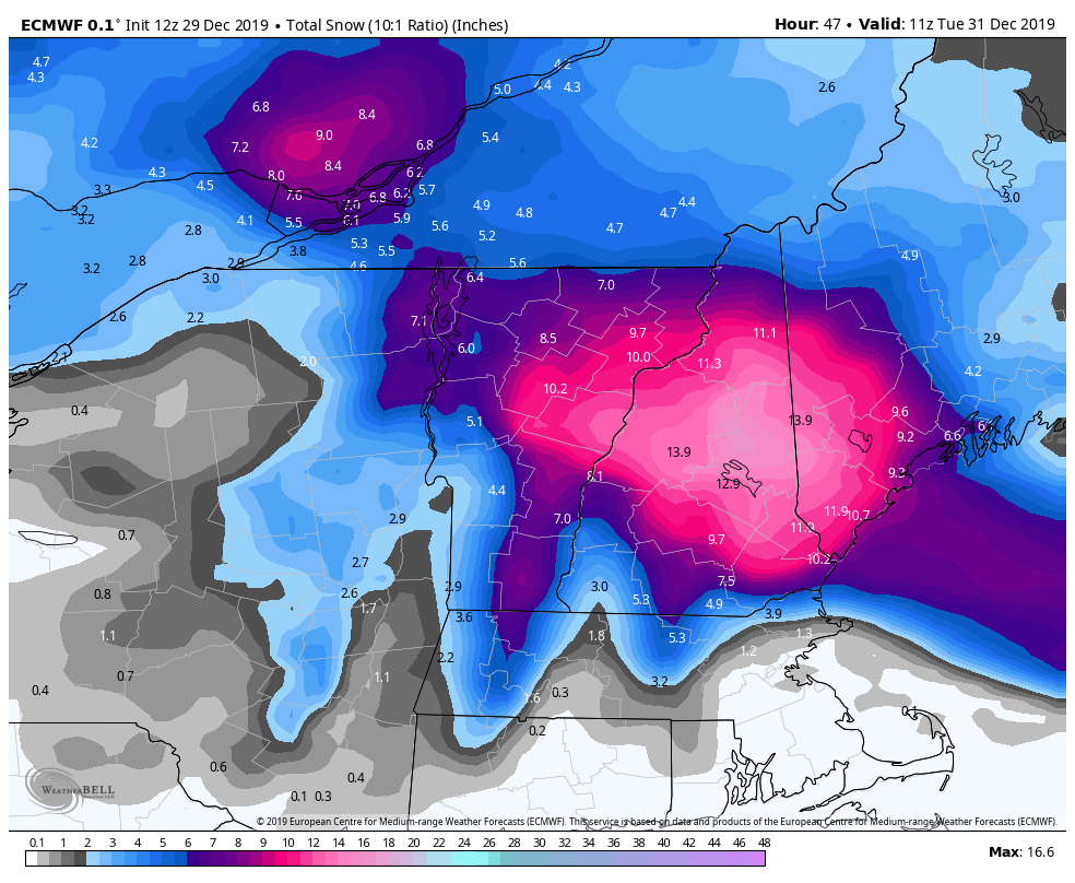
Wildcat & Attitash likely win out with snow. We’ll mix with sleet and freezing rain in the middle of the storm, but we have snow at the beginning and end that may accumulate well over 6″. There’s actually remarkable consistency on amounts surpassing double digits. Given both of the resorts do well with coastal storms thanks to some orographic lift, I think double digit snowfalls are more likely than not for our NH resorts. The Euro is pictured below through Tuesday morning. I personally think it’s a little high for amounts in NH but we can hope that it’s true!