We’re going into our second 24 hours of temperatures moving in opposite directions than they usually do, as we have arctic fronts and low pressure systems altering the normal diurnal trend. There are few days in the 7 day forecast that don’t have a “rise” at night or “fall” during the day, so I wanted to discuss a little further the pattern for the next week. Forecasts are a bit more difficult in these situations as the timing of each front/boundary is critical and the level of warming/cooling in the night/day (respectively) don’t usually follow a normal trajectory.
Cold settles in tonight with Thursday being somewhat normal (albeit windy and tundra-like) — temperatures moving as expected.
However, Thursday night, temperatures begin to rise again (though some base levels in northern New England may keep the cold during the overrunning) as our next system approaches for later Friday. This has some warmth to it, therefore we’ll have rain for the Mid-Atlantic, mixing in PA/Catskills & Berkshires (possibly southern VT/NH), and all snow for the rest. The northern extent of this system is encountering dry air, therefore northern VT, NH & ME may not see as much due to the limited moisture.

To follow with the rest of this week, Saturday’s temperatures will likely fall in the morning before steadying by mid-day. Cold returns Saturday night and Sunday before temperatures begin rising Sunday night with another quick moving low pressure system.
This brings snow/mixed precipitation ahead of it with the warm front Monday morning, and a couple rain/snow showers (along with a quick burst of warmth) ahead of the cold front Monday evening. The cold front crosses overnight, which will lead to falling temperatures on Tuesday.
It’s clear we’ve shifted patterns in terms of activity, and I don’t anticipate this stopping into February. The 15 day precipitation anomaly from the Euro Ensemble shows above average precipitation through Feb 13, and there’s more emphasis on greater precipitation for the 2/6-13 time frame.
There will be some point where the warmth wins out for everyone on one of these storms — some models say it’s the 2/8 storm signal but many systems have started warm and then progressed colder. This one has been flip flopping with each model run. Ensembles keep the 0C 850mb line around the Catskills through to coastal NH, therefore it may be a split system, or there are too many warm/cold extremes in the ensembles at the moment…so it looks “middle of the road”.
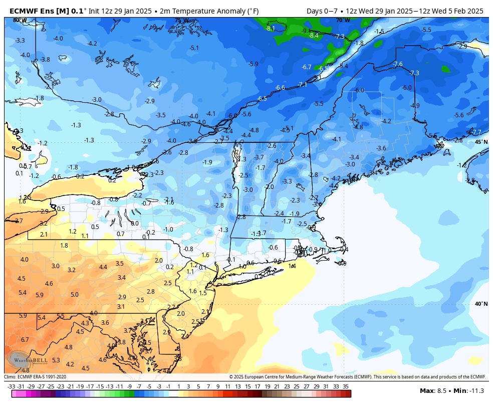
Here’s a look at the Euro ensemble surface temperature anomaly for the week ahead.
The long range has been flip flopping so much… I’m not putting a lot of stock in it. It’s not handling the conflicting variables as we talked about in the last blog, and ultimately colder air is winning out.
I do think there will be a flip to a full warmer pattern at some point in mid to late February (simply due to the whole equilibrium thing that weather patterns like) but it may not be as defined in New England as it will be in the Mid-Atlantic. It’s still not showing up with any consistency, so we’ll keep our eyes on it.