
With the extreme volatility of the season and another mixed precipitation storm coming in this week, I took a quick look at where we landed in the ENSO cycle this winter. Typically, our placement in El Niño or La Niña isn’t the “end all” for the season, but there have been some correlations made that give us some guidance on typical/atypical patterns.
Personally in my own research, which was performed on a small data set (for a mountain in northern Vermont) last summer in a graduate school data mining course, it was postulated that moderate to extreme La Niña years (and strong to extreme El Niño years) demonstrated less efficient snowmaking in the months of November through February… ~78% of the time. Efficient snowmaking was deemed <26 wet-bulb temperature. While natural snowfall wasn’t a variable used in the analysis, it can be assumed that if you can’t make snow, temperatures likely aren’t in the range for natural, with the exception of marginal events – which we’ve had many of this season.
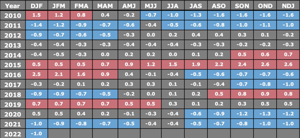
Here’s the last 11-12 years of ONI values – they are taken in 3 month increments. Weak events are in the +/- .5-1 range, moderate events are +/- 1-1.5 range, strong events are +/- 1.5-2.0 range, and extreme events are +/- 2.0 and beyond. In the fall, we were expecting to be in weak La Niña through winter with values in the fall staying > -1.0, however by late fall, they crept back to -1.0 and stayed there. That’s pretty borderline of the moderate range, but certainly could be part of the explanation of the tough early season, and lack of consistency of cold/snow during the season, as we had occasionally last winter too. It also looks a bit similar to 2011-2012, which was an abysmal winter season, and the 10 year anniversary of 80 degree temperatures at the mountains this week. In the absence of other forces (NAO, AO, etc), La Niña patterns favor inside runners for the Northeast (which have been prevalent this season), and dry but cold conditions in the Great Lakes.
The current expectation from the CPC is for La Niña to persist into the summer (therefore a similar summer season as last year), and a gradual movement to neutral by fall, which hopefully comes to fruition.