The week ahead can be split up into a couple of segments; Monday & Tuesday are cool, Wednesday-Thursday are warm & windy, Friday – Sunday are back to cool. That’s the basic summary of it all…but certainly keep reading!
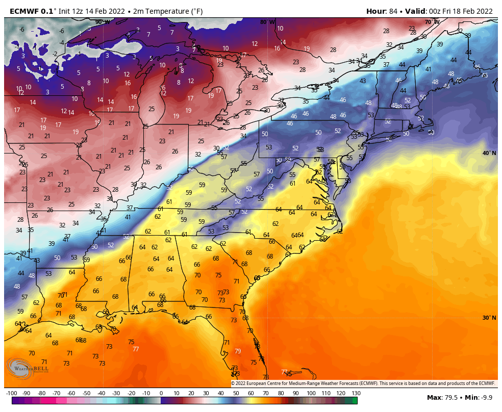
The arctic chill holds on through Tuesday morning before we start to see some moderation in temperatures. Wind picks up out of the southwest on Wednesday as a front moves across the Great Lakes, where we’ll see rain changing to snow. The front is elongated more west/east than north/south, therefore the warm sector really lives up to its name. Temperatures in the east rise to around 60 in the Mid-Atlantic, and 50’s in New England before the front crosses through early Friday morning as shown in the Euro image. By this point, temperatures in the Great Lakes are crashing with a quick burst of snow.
There’s bit a little discrepancy on the placement of the high in the northern Plains/central-eastern Canada, which has led to some colder solutions of the storm… a rain to snow switch before the storm finishes out. The placement and movement of high pressure hinges on another piece of energy swinging in from Alaska (and its speed, strength, and movement); therefore we may still see some shifts in the outcome of the end of week storm. The Euro began to trend cooler last night, but held off on additional cooling in today’s runs. The Canadian has been the most robust in the cooling. Below is a side by side depiction of their ensemble runs from 12z today.
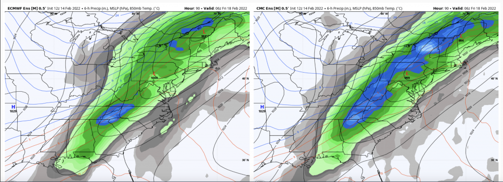
The blue/red lines are 850mb temperatures. Notice on the Canadian run they are into NW VT, half of NY and PA at this time, where it’s much farther west in the Euro. The Canadian has been pretty consistent here, and Euro is following and adjusting, which says that the Canadian may be better handling the components.
I don’t believe we’ll escape the rain completely, which as just a rain event looks to average .50-.75″ in the east (less in the northern Great Lakes), isolated amounts up to an inch – a significant rain event ahead of February vacation weeks. Both pieces of energy…the one responsible for the storm itself, and the one responsible for the placement/movement of the Canadian high pressure are not yet onshore in the Pacific. Therefore it’s possible we see some adjustments in the next 24-48 hours, however the setup does not look overwhelming in our favor.
Wind will also be a huge factor ahead of and within this low pressure. High elevation summits, especially those susceptible to SW winds, will see high wind Wednesday, Thursday, and Friday (though the change to NW occurs early Friday morning).
Behind the system and wind, we cool down to another cold air mass – not quite as cold as the one we have today but cold enough for flash freezing of any melting and non-snow precipitation Friday into Friday night in New England, and certainly some freezing possible in the Mid-Atlantic as well.