While you may not hear much of this on TV or in normal weather websites, stratospheric warming can have a large impact on the weather in the United States. Last year, it was responsible for the intense snow, ice and cold felt in Texas and many parts of the south.
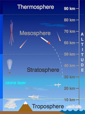
The stratosphere is roughly 10-50km into the atmosphere, the next “sector” of atmosphere above the troposphere, which is where weather lies, as do we. The image shows 4 sections of the atmosphere – missing the Exosphere, which is above the Thermosphere (think infinity, and beyond!).
The troposphere and the stratosphere are separated by the tropopause. This is the point at which we start warming temperatures with height, which is opposite of what we typically see in the troposphere (unless we have inversions). While you can’t “see” the tropopause, you can occasionally get a visual from thunderstorm anvils in the summer. You’ll notice that at some point the cumulonimbus cloud no longer grows in height, and the clouds spread horizontally. That’s the tropopause.
Stratospheric warming is defined as a mass warming event in the stratosphere, increasing temperatures by some 50 degrees Celsius in a matter of days. Given that it’s incredibly high up in the atmosphere, we don’t feel that warming at the surface, and has been linked to the opposite – incredible cooling of the United States about 30-60 days later.
Why does it happen? We have to go back to the polar vortex. This a tight ring of arctic westerlies that circle the North Pole. However, these westerlies can weaken, which leads to a break down of the vortex, and can even sometimes allow a change of direction (they become easterlies). This causes the cold air to descend quickly, which in turn causes a rapid warmup aloft – your “strat warm” event. As the cold air moves through the rest of the stratosphere and troposphere, it can causes disruptions in the jet stream, which in turn causes a change in our weather pattern.
Typically we see cold, Canadian high pressures dominate the pattern a few weeks after a strat warm. We’ll hear the phrase “polar vortex” often, and the jet stream becomes more volatile (deeper troughs/ridges), providing more opportunity for large coastal storms to develop.
The event took place just before Halloween, which means we should see some much colder intrusions of Canadian air by the end of the month and into December.