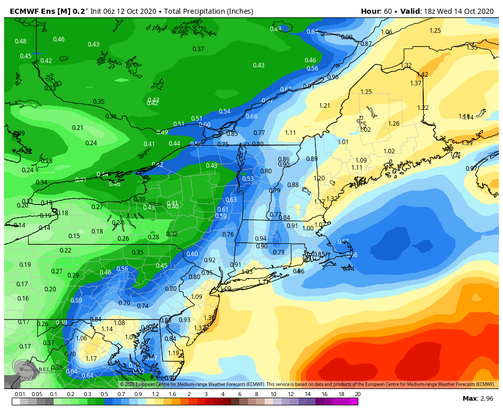
The week ahead feels quite like October. Cool breezes, more cloud cover, and several chances of rain, which we really need. The remnants of Delta converge with a low pressure system on Tuesday to bring the chance of around an inch of rain to New England. While not drought busting, it’s certainly helpful for the snowmaking ponds and rivers. The Euro ensemble is my pick for rainfall amounts, which look to be around that inch mark. The GFS is a little lower in amounts, but given the tropical nature of some of this energy, on top of the orographic lift from easterly flow, my hunch is to err on the higher side.
Behind the system, we’ll fall into a temperate, hinging toward seasonably warm pattern…but really only for one day (Thursday) where temperatures may bump back into the low 60’s. The approaching system on Friday quickly squashes that with another round of rain coming in to finish out the work week. A deep push of cold air looks to follow this cold front, especially into the Great Lakes. Base temperatures at Boyne Highlands will dip into the 30’s on Saturday morning, with areas in the interior around Gaylord & Atlanta State Forests dipping below freezing.
Several models pick up on a low moving up the east coast along the front late Friday into Saturday. There’s quite a bit of discrepancy on how the low is integrated in the front and how much cold air can intrude into the high elevations. The Euro picks up on a coastal low forming, and slams higher elevations with an early season wet snow. It would have to be perfect timing (phasing) for this to occur, but it is in the realm of possibilities. The GFS has this occurring the following week, so they are starting to pick up on the dips in the jet stream and some more energized coastal lows forming. Overall the Euro provides a more zonal, or flattened pattern heading into the weekend whereas the GFS looks to be more meridional, or more wavy. This will be something to watch. Regardless, the system will bring our second bout of significant rainfall this week.