The humid and warm “hurrah” of September has come to a close, and the weather pattern seems to be following the calendar into October with some cloudy, cool, and showery conditions. The shower activity, as small as it may be, is welcomed in our severe drought situation in New England. Thankfully we’re much better off in Michigan.
National Weather Service, Gray Maine
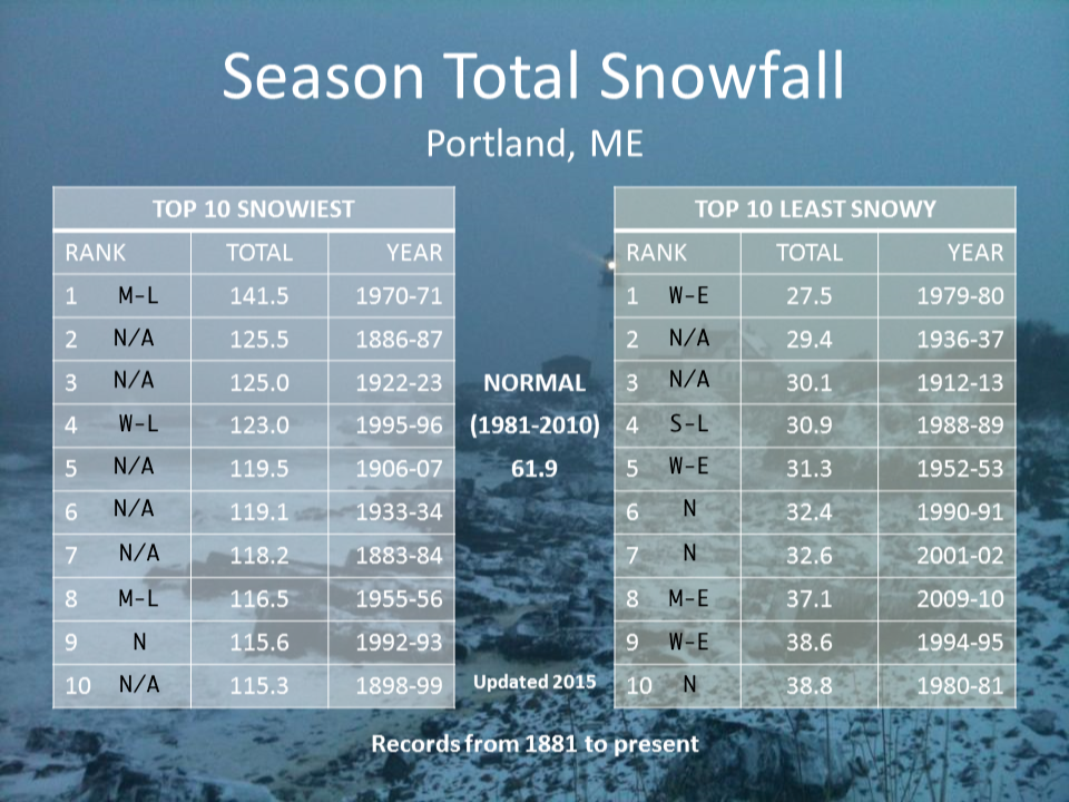
There’s been lots of talk about the winter ahead with La Niña conditions settling in. However it’s important to note that there are no direct correlations in eastern snow and where we are in the ENSO cycle. Based on Portland, Maine snowfall records, the top 10 snowiest winters have come in neutral and weak/moderate cycles of La Niña. Our least snowy winters have been in neutral, weak/moderate El Niño and strong La Niña. We were in a weak El Niño phase last winter and received 59.6″ for the season. The best we could say is that weak to moderate La Niña winters give us the potential of high snowfall, and vice versa for weak/moderate El Niño, but not sure how much help that is anyway. Also good to keep in mind, is that ENSO records only go back to 1950, whereas temperature/precipitation observations go back to the late 1800’s in some cases. Therefore there’s only so much data to touch upon. Here’s the graphic used from the National Weather Service in Gray for reference – I added in the ENSO state under the rank.
So where are we headed now? Into a weak, potentially low-end moderate La Niña. Somewhat promising, but not at all definitive. Analogs reviewed earlier in the summer somewhat resembled 1995-1996 winter. That always brings a smile to my face as it was the Blizzard of ’96 that brought on my love of weather and ultimately lead me on the path to being a meteorologist. After a full season in 2019-2020 without a nor’easter, and no “blockbuster” storm in 2018-2019, the thought of a 1995-1996 repeat is exciting. Not too exciting though, because extremes come with other extremes; the atmosphere likes equilibrium. If you swing one way, you’ll eventually swing the other way. That’s why 2018-2019, a steady-state winter of small to moderate snowfalls is actually a best case scenario (which was a weak El Niño; see what I mean? No correlations). Big storms and big cold come with eventual swings to the other side.
Which leads me into a shorter-term long range outlook, which is what most of these updates will encompass. These will come each Friday throughout the season. What are we expecting in the next 7-14 days?
Cool and cloudy conditions prevail through Wednesday of next week, along with some showers. The rain is much needed at this point as most bodies of water are severely lacking. The US Drought Monitor does label this as a short-term drought, which has actually been a consistent feature for the last 4-5 summers; dry end of summer, early fall – followed by a replenishment in late fall and with snowpack over the winter. It starts to become more interesting later next week, when a deep trough digs into the eastern US.
This is pretty potent for early-mid October, and may drop temperatures well into snowmaking ranges for over 24 hours in elevations >2500 feet from later Thursday through a portion of Saturday. Wind will be a factor, with very gusty winds out of the northwest expected after the frontal passage. Below 2500 feet, we may have a 6-10 hour window Thursday night into Friday morning where we drop into snowmaking ranges, but much more marginal. Wind begins to shift Saturday, and that will bump us out of that window by late morning. Of course timing may still shift slightly as we are still one week out from this physically developing, but the cold certainly looks like it’s coming for that time frame.
What goes down, must come up. Notice to the west of the trough in the east, is a ridge to the west. That ridge swiftly moves back into the east later next weekend, and looks to hold for a couple days (10/11-10/15) before the next trough (seen over the Pacific) moves in (~10/16). What this tells us is that we’re headed into a fairly volatile pattern for much of October. There’s also still some tropical features lingering, and in this type of pattern, the system is either shunted away by the trough if it’s settled in the region, or could be picked up by a front/low pressure if we’re in transition (think October 2017, The Perfect Storm of 1991).
While we see some decent October cold in the future, it’s just one part of the rollercoaster ride. We’ll be up and down quite a few times, with some powerful systems to come through in the time period as well.