As we mentioned in the previous blog, with the NAO and AO staying overwhelming positive, we’ll be hard-pressed to see all snow events for our region. Events will be marginal and we’ll likely see rain and snow events in the same week, or for this week, nearly in the same storm.
Arctic air settles in only briefly in these patterns, because there’s nothing to really seal it in. So while we’re not exactly toasty today, or tonight, we’ll see that warm air move in quick.
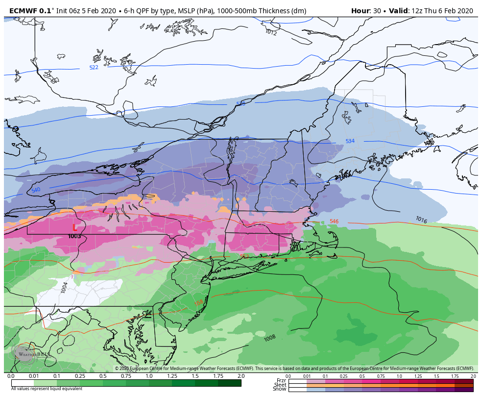
What’s holding it back, is cold air damming. We’re at the mercy of cold air damming for most storms in this pattern, and it does look fairly strong in this scenario. Still, it does not look strong enough to keep the warmth out of the entire atmospheric column, therefore we’ll be left with some sleet and/or freezing rain instead of snow.
We actually get a nice burst of snow to start the system Thursday morning. Mount Snow is likely to see 1-3″ before any mixing comes in, and Attitash/Wildcat should hit 2-4″ (if not 5″ at the cat). Hunter even gets in on the fun with 1-2″ before the switch to freezing rain, and sleet. This will start out as dry snow, eventually become more of a wet snow as the temperatures rise.
What as been a little inconsistent is how quickly the cold air leaves any level, but also the intensity of the precipitation plays a big part too. If the depth of the non-freezing layer isn’t very broad, and the snowflake moves through it so fast because of the sheer intensity of the precipitation, then we could theoretically see snow even when there’s a warm layer aloft. This may only buy us another hour or two of snow, because eventually the warm layer looks to be 1,000-2,000 feet deep, but that hour or two of snow may be some of the heaviest precipitation we get with round one – so it would make a big difference.
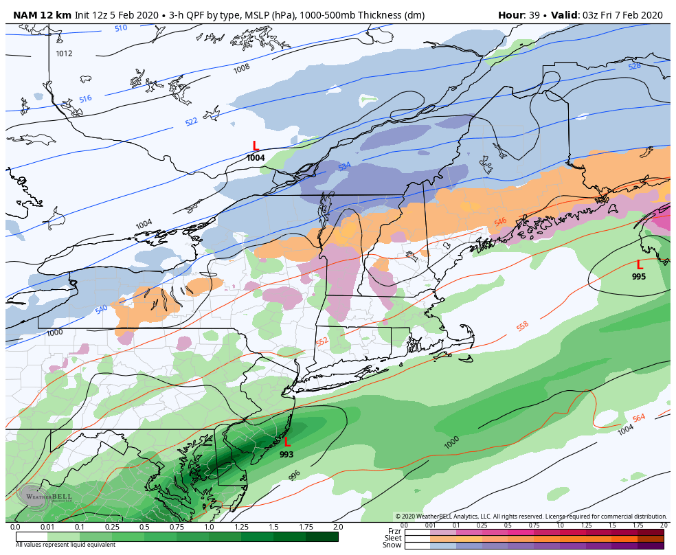
Between the two waves, we’ll be dry slotted – it’s a region of dry air that gets ingested from the low, typically from the southwest. It happens in most storms, but we’ll have another low coming up to kick it out fairly quick. While we see the dry slot, temperatures will likely move up, and we’ll see freezing drizzle/drizzle across the region. This is when there’s the largest concern for icing, as it’s hard for ice to accrete to aerial surfaces when there’s high intensity, but rather when it’s drizzle or very light rain. The second low begins to crank near Long Island, NY, and we’ll see the next round of heavy precipitation coming in.
This will likely start out as rain for Mount Snow and Hunter, a mix for Wildcat and Attitash. But as that low cranks, we pull in cold air from the north, and the snow bands crank up. This is when the sheer intensity may actually help to wash out the warm layer, part of what we call “dynamic cooling”, and will start the transition from rain/mix to snow. I anticipate this to occur by early afternoon.
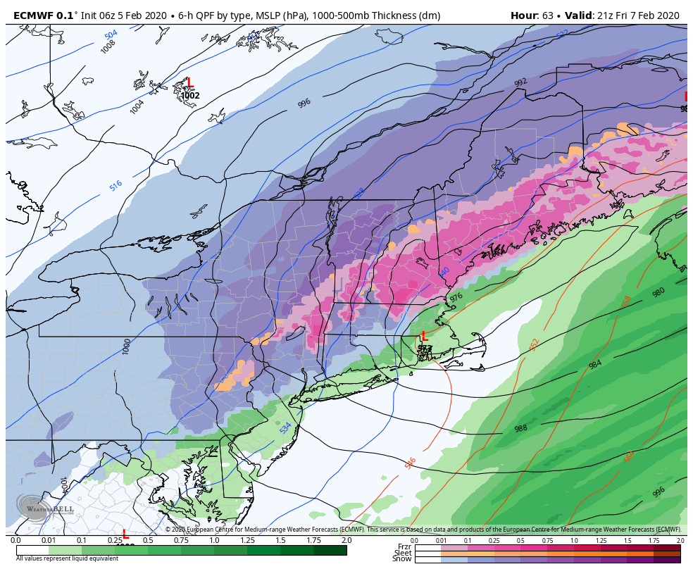
The image to the left is valid at 4pm on Friday, and there are some serious snow bands there that could easily bring 1-3″/hour rates of snowfall. It will start off as a wet snow, and eventually come out to a drier snow by the end. The snow should depart by 7-8pm.
The backend of this system could provide some big snow in a small amount of time. My forecast that you see on the dashboard is more conservative, as they typically run, but in the ideal scenario, we could see 4-6″ at Mount Snow and 6-10″ at Wildcat/Attitash after the mixed precipitation. Stowe would be the Vail winner, probably adding up 8-12″ in a good scenario, well over a foot if the snowfall ratios come up quicker than forecast right now. Hunter could see 2-4″ too.
So while it is indeed, a mess of a storm, we may finish it out on top. In terms of weekend expectations, the arctic plunge does come back in for Saturday, so whatever moisture was left in the snow, will disappear quickly and it will be a cold day. Sunday’s temperatures moderate nicely ahead of some light precipitation coming in Monday.
Will continue to monitor for ice and heavy snow potential, and update once more before the storm is done.