We have an incoming storm that all in all, isn’t very different from the last one if you look at the amount of liquid coming down. It’s a little larger, but same speed and low track. However, we’ll actually have some really interesting snowfall discrepancies, especially when you compare Hunter/Mount Snow to Wildcat/Attitash.
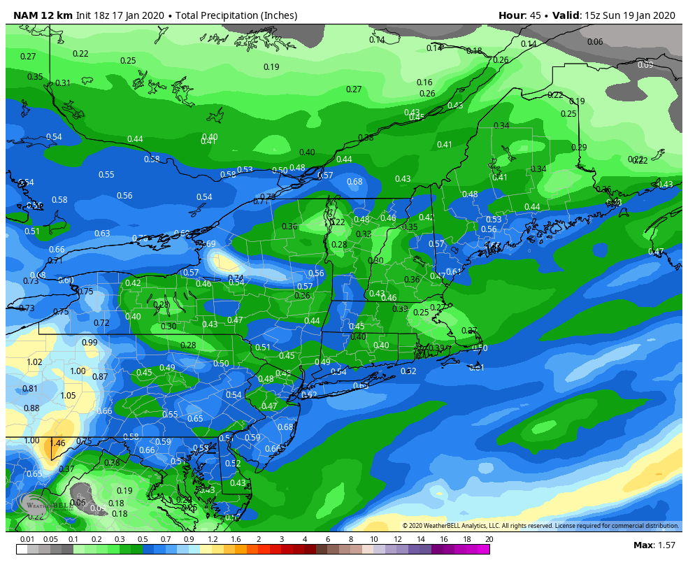
The first image is the total precipitation projected for the storm. This is considered “liquid” – so we’re taking precipitation type out of it, but if you melted everything and it was all water, this is what would fall. Notice that Mount Snow actually should have more liquid falling than Wildcat/Attitash. Hunter is about the same for liquid, so you might think that the snowfall amounts would be within an inch of each other.
I’m expecting 3-4 more inches at Wildcat/Attitash than Mount Snow and especially Hunter – this is because of the snow to liquid ratio (or equivalent). The snow ratio is how much volume of snow you get for a given volume of water. A typical ratio is 10:1 – meaning for one inch of liquid, you receive 10″ of snow (makes some cold rain storms even more annoying now, huh?). That’s an average ratio, but it doesn’t always work.
Let’s take these scenarios:
Temperatures above freezing, near freezing – “wet” snow: When you hear about wet snow, it’s usually a high water content snowflake or cluster that is more than 50% ice before hitting the ground – any less than that and it would have more characteristics of a raindrop. The high water content is because it’s partially melted before getting to the surface. You get these clusters of snowflakes when temperatures are close to freezing because the partially melted snowflakes bang into each other, and stick together. So the snowflake really isn’t the size of a golf ball – enough snowflakes have just stuck together to look like a golf ball. These ratios are typically 6 or 7:1 – which means for that same inch of liquid, you’re only getting 6-7″ of snow. It’s using up that much more moisture in the amosphere for each snowflake, instead of creating more snowflakes, so to speak.
Temperatures well below freezing – “dry” snow: Dry snows have very little moisture content. When the temperature is low, the moisture in the atmosphere is low. Moisture content of the atmosphere increases exponentially with temperature (think of when there’s 100% humidity at 20 degrees, it doesn’t feel “humid”), so when we’re down this low…there’s not much moisture to work with. Dry snow flakes are less dense than wet snow flakes, and there will be lots of air pockets in the crystals. Instead of getting these big, clumpy snowflakes all sticking together like a mound of concrete, you have substantially more tiny ice crystals that are accumulating. This is the type of snow you can use a leaf blower clean up, or what we love to call champagne powder. These ratios can be up toward 20-30:1 in mountain environments, so yes, in that same inch of liquid, you could see 20-30″ of snow.
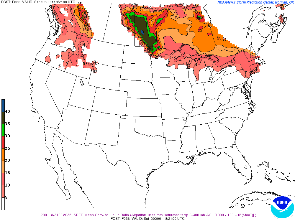
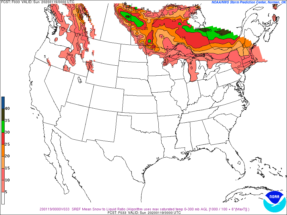
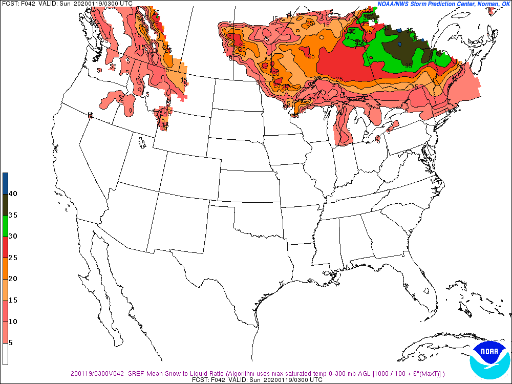
For this upcoming storm, we are going to see varying snow to liquid ratios from eastern NY/southern Vermont to northern New Hampshire – therefore while we may see more liquid actually fall at Mount Snow, the highest snowfall amounts are likely to fall in NH. Temperatures boost up into the mid, even upper 20’s to finish out the storm at Mount Snow (and actually get above freezing at Hunter), which will highly impact ratios. Since ratios won’t be terrible at Mount Snow/Hunter for the entire time, I anticipate a better ratio than 6-7:1, but you’ll notice a definite difference in composition of the snow from beginning of storm to end, whereas you may not see much difference at all at Wildcat/Attitash.
Here are snapshots of the expected ratios from 4pm to 10pm on Saturday.