Our last blog was about teleconnections and some signs that our 12/17 system would likely be cooler than the washouts we had previously. We spoke of freezing rain and rain for PA (which was more freezing rain than rain), snow/ice for Hunter & Mount Snow, and all north snow. Mount Snow was mostly snow – a little graupel in there – but Hunter did see snow/ice while Wildcat and Attitash remained snow.
All in all, the teleconnections and analysis of them 7 days ago proved to be a solid preview of the upcoming system. Now that we’re looking at the all important holiday weeks – what’s next? And what about this arctic blast?
The previous blog highlighted Dec 19 as an area of interest, nothing major, and the teleconnections were signaling the arctic front coming through – or you’ve probably heard “polar vortex” a couple times this week.
We’ve actually gradually built up to this subject with previous blogs on StratWarms and teleconnections. The good news is that we can first relate the Polar Vortex to the Arctic Oscillation. “Vortex” refers to the counter-clockwise winds (westerly) around the low pressure, and “Polar”, because we’re up in the poles.
Essentially, the Arctic Oscillation is the measure of the Polar Vortex strength. This is a permanent low pressure at our poles that is there all year round. The polar vortex doesn’t appear and reappear, it’s always there. It just doesn’t always say hello to the Northeast. When it does, we’re in a negative AO phase and the strength of the Polar Vortex has weakened.
When sudden stratospheric warming occurs, we have a breakdown of the core counter-clockwise (westerly) winds – remember occasionally they even turn easterly. So when this breakdown begins, we no longer have this tight core of wind, and it gradually expands southward, and eventually affects the jet stream. The jet stream gets nudged south, the cold air filters in, and it affects the entire weather pattern.
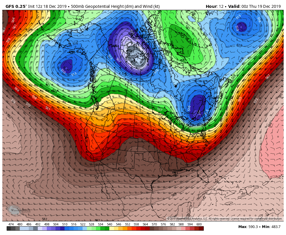
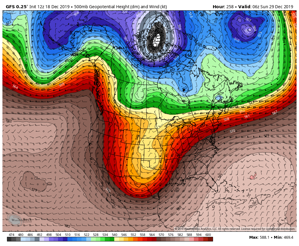
Notice the connection to the core of low pressure closer to the North Pole of the segment flying into the Northeast Wednesday night (GFS image for 12/18).
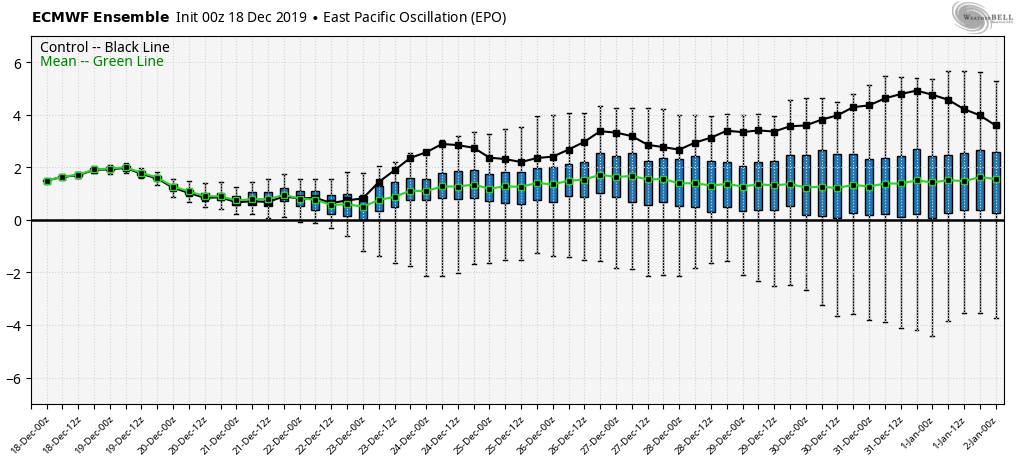
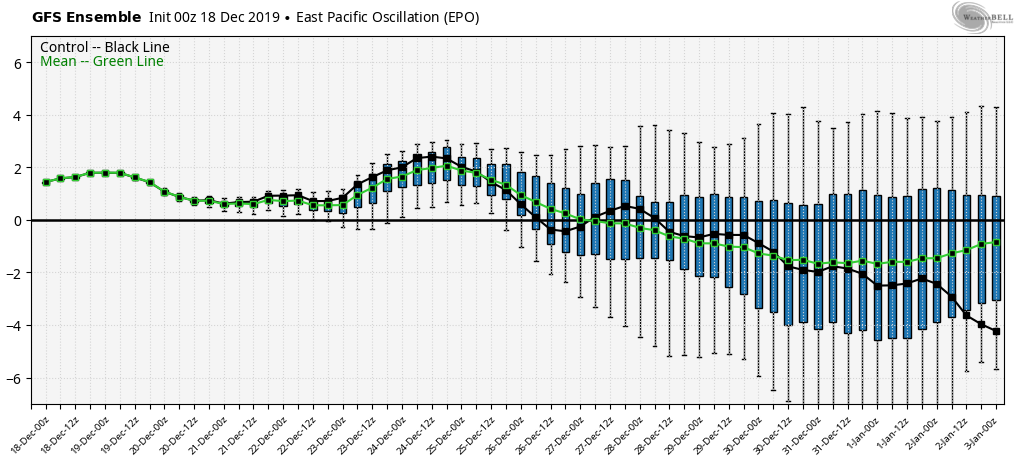
Our AO is going negative into 12/18, which makes sense with this cold blast. However, when comparing the two GFS images shown, notice when we get closer to New Years, how much “tighter” that core looks, and less intrusions occurring from that central area of low pressure – and also how much less “wavy” the overall pattern looks. That’s some insight to our post Christmas weather pattern.
So what are we looking for the holiday week? Through Christmas itself, we actually have fairly decent agreement on a quiet but cool pattern. After the snow showers/squalls associated with the arctic front, there’s not much more to our precipitation outlook. The AO/NAO looks to stay negative through 12/26. We’ll have some moderation into 12/22-23 with base temps in the 30’s but no real warmth. It’s at the post-Christmas point that there’s major divergence in the teleconnections on settling back into the winter pattern, or hanging out in this moderation. The next significant system arrives around 12/29, but it is too early to tell which way it’s going to pull. Typically you need you get through a major pattern change (arctic front) before you can clearly see the next one. Shown below is the EPO (Eastern Pacific Oscillation), which gives us an idea where the troughs/ridges are setting up. Most positive EPO patterns usually are not good for Northeast snow.